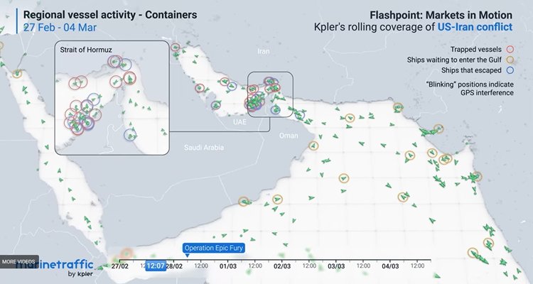
Iran’s threat to Persian Gulf shipping is portrayed as one of military strikes against commercial vessels. But the threat is much worse than that.
Ships don’t know where they are or where they are going. They can’t avoid other ships except by sight navigation. They also can’t report their positions in order to be rescued after a strike, grounding, or collision.
Haywire
CNN reports that “Within 24 hours of the first US-Israeli strikes on Iran, ships in the region’s waters found their navigation systems had gone haywire, erroneously indicating that the vessels were at airports, a nuclear power plant and on Iranian land. The location confusion was a result of widespread jamming and spoofing of signals.”
Commercial shipping has been using America’s antiquated Global Positioning System (GPS) as their standard to navigate—the publicly available version. Incoming U.S. missiles and drones are using the encrypted and more accurate military version of GPS.
Judging by the successes claimed by the U.S. and Israel, we can conclude that Iranian missile jamming has not been very effective, if at all, against military GPS. And although no one should expect that the U.S. and Israel are using commercial GPS to wage war, it’s possible that on the lower end of the weapons-quality scale, drones, especially commercial drones, do use publicly available GPS to navigate.
We have seen this movie before. Early in last summer’s conflict, Iran was using commercial GPS, and
Israeli electronic warfare units deployed high-power jamming transmitters capable of overwhelming GPS receivers by flooding the electromagnetic spectrum with interference signals that masked legitimate satellite broadcasts.
This electronic saturation forced Iranian drones relying on GPS navigation to lose positional awareness mid-flight, resulting in multiple aircraft crashing or veering away from intended targets before reaching Israeli airspace….
[But] as early as 2022, Tehran [had] initiated efforts to integrate [Red] China’s BeiDou-3 [BDS] navigation system into its military infrastructure, anticipating scenarios in which reliance on U.S. satellite navigation signals could become a liability during future conflicts.
To some extent, the Iranians were able to switch from GPS to BDS in mid-war. “Declassified reports from the conflict indicated that Iranian weapons using BeiDou-3 achieved a positioning reliability rate of approximately 98 percent even under heavy electronic warfare conditions.”
The BDS advantage
That is very impressive. It means that Iran’s opponents now have to knock out launchers and sites in order to reduce hits by precision munitions.
Before adopting BDS, Iran would have to saturate a target and hope that some stuff would get through (what Hezbollah is doing now with its non-precision missiles).
As with GPS, BDS has a commercial side and a military side that is not available to commercial users.
This [military BDS] Short Message Communication feature enables users to transmit short data packets of up to 560 bits directly through satellite links across distances reaching approximately 2,000 kilometres.
Such capability becomes particularly valuable in contested environments where conventional radio communications may be jammed or where satellite phone transmissions risk interception.
During the Twelve-Day War [in June 2025], this bidirectional communication function enabled Iranian command centers to maintain continuous contact with weapons systems operating deep within contested airspace.
Military analyst Patricia Marins says that with this communications capability, weapons could be redirected after launch if circumstances change. “Unlike the civilian-grade GPS signals that were paralysed in 2025, BDS-3’s military-tier B3A signal is essentially unjammable.”
Goodbye preprogrammed coordinates.
Meanwhile, GPS has rolled out its GPS III and Space Force has launched its first GPS III satellite.
The GPS disadvantage
At least one user group is not happy with GPS III, an example of “doing the same thing and expecting different results. GPS satellites are great! They do exactly what they are supposed to do. The problem is that these kinds of signals are weak and therefore easily jammed, and specs are public so they are easily spoofed.”
Sean Gorman, writing in Space News, is more severe.
GPS III represents an iterative update rather than a paradigm shift, improving accuracy, extending service life and strengthening resistance to jamming through higher signal power and spot beam technology. While these enhancements improve reliability in contested environments, they don’t fully address sophisticated jamming threats or close the gap with competing systems like BeiDou….
Today’s adversaries do not need to defeat GPS globally or destroy satellites in orbit. Instead, they rely on persistent, localized disruption at the receiver level using mobile jammers, spoofing systems and electronic warfare integrated into broader campaigns. These techniques are inexpensive, highly scalable and already in widespread use. In this environment, the limiting factor is not satellite performance alone, but dependence on a single space-based signal. GPS III hardens the system at the margins, but it does not fundamentally change that dependence.
When you consider how heavily the U.S. War Department depends on GPS, the situation is very discouraging.
GPS is now the core technology system for U.S. Military aircraft, vessels, vehicles, and personnel, and provides an indispensable tool, providing precise time and location.
GPS is integral to aircraft navigation systems, as it provides positional data and allows for precise targeting. Unmanned aerial vehicles also rely on GPS for autonomous navigation. Land vehicles can navigate complex terrain with GPS, and soldiers can use wearable or portable GPS devices to maintain situational awareness, navigate, and improve safety. It is also crucial for naval vessels to use GPS to plan their routes and navigate safely.
All of this is subject to “persistent, localized disruption at the receiver level using mobile jammers, spoofing systems and electronic warfare.” All of it. U.S. warheads have been getting through this time. But next?
And in the meantime, ships lie immobile in the Persian Gulf. □
James Roth works for a major defense contractor in Virginia.
Also see:
StoptheCCP.org: How China’s BDS Is Clobbering America’s GPS